
https://www.youtube.com/watch?v=WOVfG4H_bS4
I am pretty sure there are toll stations in Slovenia, but they are completely electronic, I don't think there are any tolls in in-game Slovenia, I could be wrong though since I haven't been in Slovenia for a while.
Balkans Development
-
Audi1merc2
- Posts: 181
- Joined: 04 Nov 2017 08:23
- Donation rank:

- Location: Bedford, United Kingdom
-
NiclasHopsi
- Posts: 9
- Joined: 24 Oct 2014 13:46
- Location: Chemnitz, Germany
No, there aren't any toll stations in Slovenia anymore. Until 2018, trucks needed to pay at toll stations (thats why the video is called "A farewell to toll stations"). Since 2018, trucks (and other vehicles over 3,5 tons) are required to have a electronic toll collector on their windshield like in Austria for which use no toll station is needed.
I was in July and November 2019 in Slovenia and I saw that they removed fairly all toll stations.
I was in July and November 2019 in Slovenia and I saw that they removed fairly all toll stations.


-
zmaj_od_istre
- Posts: 48
- Joined: 23 Aug 2017 11:39
Ok, I must say that I am satisfied. Very satisfied. It seems that Istria coming to Promods, and wow, in a big style!
It looks so good. I can recognize every place on the image. I am a bit curious. SeptianPJ, you are from Indonesia, right? Have you ever visited the Istrian peninsula? As from the images here, you nailed it
Also, can you tell me more about the map? How were you able to implement all those locations in the limited (very limited) space on the map. I suppose Koper is also included, and that with Pula, those are two cities on the peninsula.
Istrian Y is the main road artery, right? I can see Tunel Učka - so the connection with Rijeka is in the game, as it is connection with Koper/Trieste - Mirna Bridge. I suppose there are is no place for the coastal roads, which are very beautiful, especially the part along Kvarner bay (Opatija Riviera). And did you include any landmarks? I see Pula amphitheater, but depending on the space you could add Dvigrad (it is visible from Y when the road passes near Limski fjord - yes we have the fjord
Dvigrad is a ruin, and Motovun is a picturesque medieval town, so they could be just eye-candy assets. I have a few more ideas depending on the size of the area if you are willing to include them.
Here you have Dvigrad, with one of bridges of Y, or viadukt visible in the distance
https://visitkanfanar.hr/wp-content/upl ... 24x576.jpg
And here is a picture of Motovun (you can see Mirna river in the background)
https://en.wikipedia.org/wiki/Motovun#/ ... l_view.jpg
Last edited by Trucker2223 on 08 Jun 2020 21:03, edited 1 time in total.
Reason: removed images, please don't quote images
Reason: removed images, please don't quote images
-
Septian_MR
- Posts: 198
- Joined: 11 Nov 2015 04:04
Glad you like and recognize it  . Istria part was really chalenging to create, because of map space issue. But now it's revealed and definitely ready for 2.50.
Yes, I am Indonesian who is mapping many places in PM Balkan Area (seems nobody know about this ). In fact, I have never been in Balkan in real life (but there are few of our member team who have visited there, even to Istria
  ). At least, images from Google Street View (although it's very very old), Mapilarry, and many recent Dashcam driving videos from Youtube help me a lot.
Koper is also included as well. Only main road and junction have been added, which are the major connection to that peninsula (i.e E 751).
Yes, for now only Istrian-Y road is included in map. Making some beautiful coastal roads would be difficult because of map space issue.
For landmarks, there are only few in centre of Pula (yes, like the Amphiteather as you said). Maybe adding more landmarks will be nice feature .
Anyway, Terima kasih! (means thank you in English).
.
.
.
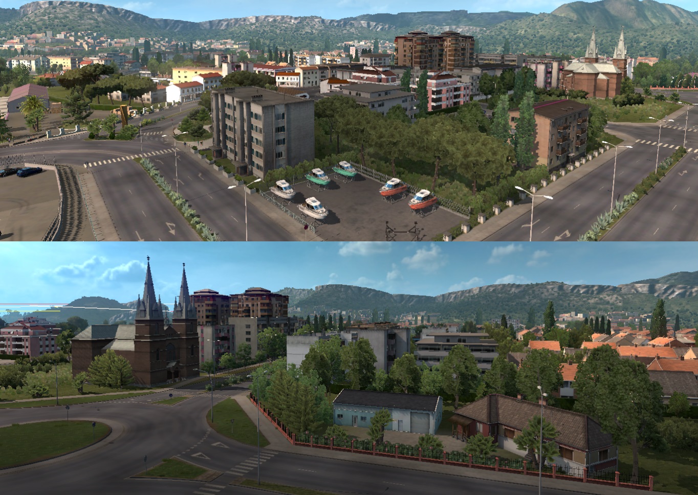
And a small surprise for everyone. This new place will be ready for 2.50!
Yes, I am Indonesian who is mapping many places in PM Balkan Area (seems nobody know about this
Koper is also included as well. Only main road and junction have been added, which are the major connection to that peninsula (i.e E 751).
Yes, for now only Istrian-Y road is included in map. Making some beautiful coastal roads would be difficult because of map space issue.
For landmarks, there are only few in centre of Pula (yes, like the Amphiteather as you said). Maybe adding more landmarks will be nice feature
Anyway, Terima kasih!
.
.
.
And a small surprise for everyone. This new place will be ready for 2.50!


omg montenegro
-
Septian_MR
- Posts: 198
- Joined: 11 Nov 2015 04:04
-
Gabrielius_logistic
- Posts: 101
- Joined: 27 Dec 2018 23:49
- Donation rank:

As I understand, Bar will be accessed through Bosnia and Croatia (road Nr. 8) Does it mean that Neum and / or Dubrovnik will also be available in 2.50?
-
Gamereality
- Posts: 25
- Joined: 08 Sep 2019 06:33
They have been confirmed already
Last edited by bmwGTR on 10 Jun 2020 12:20, edited 1 time in total.
Reason: remove quote, please do not quote the post above yours
Reason: remove quote, please do not quote the post above yours
-
- Information
-
Who is online
Users browsing this forum: Baidu [Spider], Google Adsense [Bot], Kreciuu and 11 guests