Page 14 of 15
Re: DLC Arizona
Posted: 12 Jun 2016 07:04
by Mr Larrington
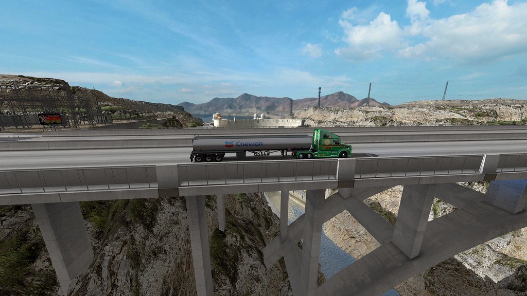 Hoover Dam
 by
Mr Larrington, on Flickr
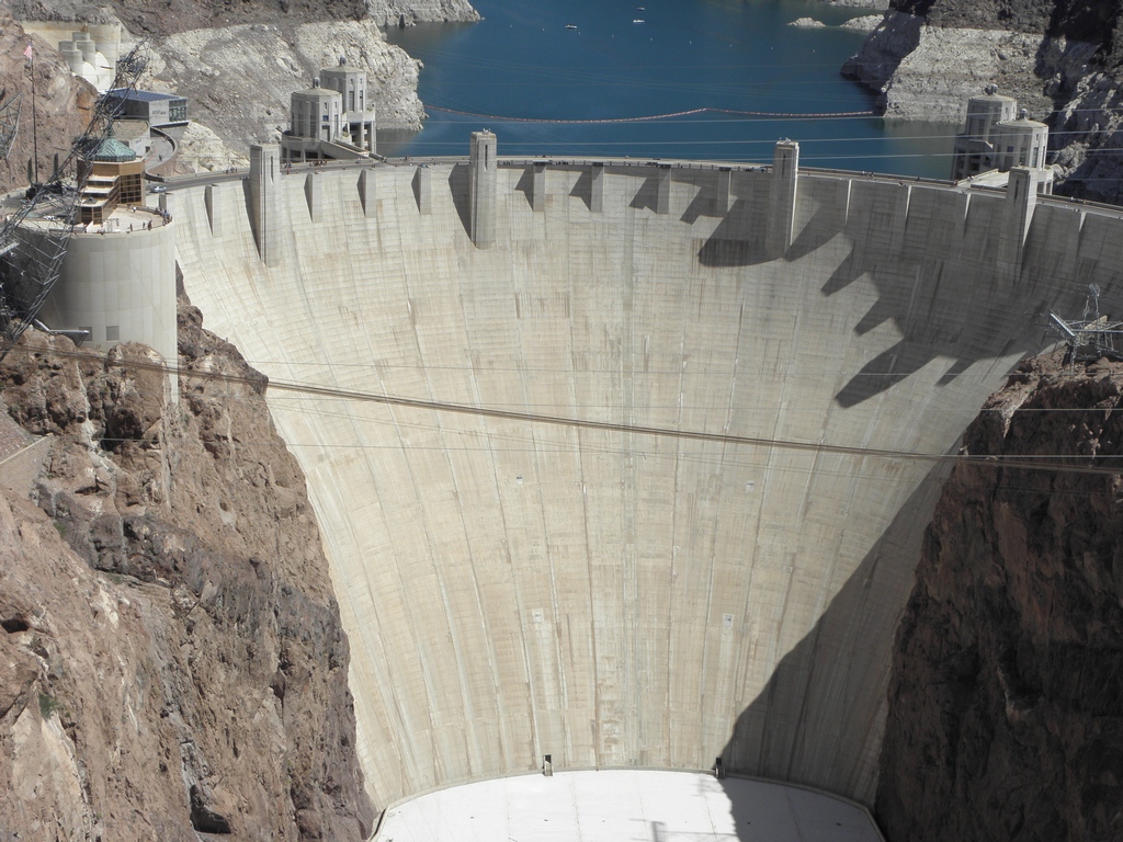 And the real thing
 by
Mr Larrington, on Flickr
I didn't take my jet-pack on holiday in 2014 so couldn't get the bridge and the dam in the same photo

They have got the coniferous forests on I-40 west of Flagstaff, which is nice. Kayenta doesn't have enough gas stations. Further exploration is still required to see how it matches up to my recollections and/or photos but I bet it doesn't include me hiding from the noon-day sun under the bridge carrying I-10 across the Mighty Colorado...
Re: DLC Arizona
Posted: 12 Jun 2016 10:18
by jdenm8
Seligman's landmarks are in Kingman. Which is weird, since the connection between I-40 and AZ66 is clearly BUS I-40 and the scenery town is clearly Seligman.
The scaling strikes again.
Re: DLC Arizona
Posted: 12 Jun 2016 20:31
by Callipso
Scaling is terrible, makes everything seem all bunched up and takes only a few minutes to get from Kingman to flagstaff. The worst thing is there is no representation of elevation in the game at all. In Arizona if you are heading toward Flagstaff you will expect to gain significant elevation in the game, this takes a toll on all trucks passing through the state and I frequently see them pull over on the areas where there are grades that are significant. if your coming from Phoenix which is at around 2,000 ft and go toward Flag you will gain 5,000 ft overall. Flagstaff is at 7,000 ft. there are also mountain ranges in the way so you would have to deal with the up and down of crossing those 2 other ranges (Manzatnal Mountains and the Black Hills) and then climbing the Mogillon Rim. None of that elevation is represented and it feels like its just a joy ride through the state.
Re: DLC Arizona
Posted: 12 Jun 2016 21:46
by Shiva
Yeah, that Scaling.... 1:19 or whatever ETS2 uses, would have been better.
Callipso wrote:Shiva wrote:
Flagstaff? The green city of Arizona? Spruce's, green grass, etc?
Similar to google maps atleast.
Figured as much nothing close to reality then. None of those things are common in Flagstaff. Green, okay I'll give you that one.
What?! google map lies?!
WTF?!
Or is it Spruce's that look Pines?
Did you yet visit Flagstaff in ATS?
Route 66 That walkpath is not ingame.
US-180 North of Flagstaff.
Wait, I do see Spruces too. And something that resembles Pines.
Re: DLC Arizona
Posted: 13 Jun 2016 22:18
by Callipso
Shiva wrote:Yeah, that Scaling.... 1:19 or whatever ETS2 uses, would have been better.
Callipso wrote:Shiva wrote:
Flagstaff? The green city of Arizona? Spruce's, green grass, etc?
Similar to google maps atleast.
Figured as much nothing close to reality then. None of those things are common in Flagstaff. Green, okay I'll give you that one.
What?! google map lies?!
WTF?!
Or is it Spruce's that look Pines?
Did you yet visit Flagstaff in ATS?
Route 66 That walkpath is not ingame.
US-180 North of Flagstaff.
Wait, I do see Spruces too. And something that resembles Pines.
To answer you questions.
1.) I do not own ATS though I have seen enough on YouTube of the final product to get the idea.
2.) At times Google maps is out of date. though likely the photos of Flag are current
3.) these are the common types of trees around and near flagstaff.
Ponderosa Pine
Proliferates the area to the west and south, ending at the Mogillon Rim. grows above 6000 ft
Utah Juniper
Found in combination with other Junipers and Piñons starting at about 4500 ft and overtaken by larger pines at 6000 ft
Rocky Mountain Juniper
see above
Two-needle Piñon
see above
One-seed Juniper
see above
Quaking Aspen
found in groves around the flagstaff area, pretty selective about where they want to grow. Typically likes lots of water retention in the soil.
Englemann Spruce
Spruce tree that does grow in this area, extremely unlikely to be found below 8000 ft, mostly found on Kendrick Peak as San Francisco Mountain is covered in Aspens at this elevation.
Limber Pine
Likes higher elevation than flagstaff, almost confined to the Peaks
To answer the question, Spruce can grow here, if they are either planted by landscapers as they wouldn't be native, or if where you were looking at was above 8000 ft. Most all roads that you drive do not reach this elevation. Likely what you were seeing was the local set of pines, do they look similar to the native pines? I wouldn't say so, but we could argue all day about it and not get anywhere.

Re: DLC Arizona
Posted: 16 Jun 2016 02:34
by Shiva
Nice, I'll ask you if I need named to the different trees and bushes

Vegetation around Flagstaff to Grand Canyon Village ain't that bad ingame.
The scale used on the other hand......
Still wondering WHY they decided to use the current scale ingame.
Re: DLC Arizona
Posted: 18 Jun 2016 07:57
by Mr Larrington
Agree about the lack of climbing from Phoenix up to Flagstaff - I've just been that way and no downshifting required. It could do with Navajo Bridge and the road west to connect with I-15 north of Vegas too.
Re: DLC Arizona
Posted: 18 Jun 2016 21:05
by Callipso
could have also done the old hwy 89 (89A) route, that would include Mr. Larrington's Navajo Bridge idea, to the North Rim of Grand Canyon, it also serves as a quicker route to Fredonia, AZ and Kanab, Utah. Fredonia connects to Saint George via SR389/59 while in Kanab 89A rejoins 89 and provides access to the Grand Staircase region, Zion Canyon via SR9, Bryce Canyon via SR12/63, eventually connecting up with I-70 heading toward Grand Junction/Denver
Re: DLC Arizona
Posted: 19 Jun 2016 16:58
by Shiva
89 might continue whenever they SCS builds Utah.
89A ? well... maybe if ProMods does an USA map.
Re: DLC Arizona
Posted: 19 Jun 2016 23:05
by ScuL
I've driven both 89 and 89A in real life twice, quite familiar with the situation there. Last time 89A was still closed due to the rock slide that led it to become A