


The logical steps now would be:
1. Reach Limoges and Clermont-Ferrand (maybe Angouleme?)
2. Connect Bordeaux with Lyon (and everything to the vanilla map)
3. Get to Bayonne, Pau, and the Spanish border (already half-made)
4. Toulouse
5. Montpellier and Millau
So, just wait and enjoy.
Development on version 1.x (France edition)


Exactly, just sit back and relaxjontsuba wrote:The logical steps now would be:
1. Reach Limoges and Clermont-Ferrand (maybe Angouleme?)
2. Connect Bordeaux with Lyon (and everything to the vanilla map)
3. Get to Bayonne, Pau, and the Spanish border (already half-made)
4. Toulouse
5. Montpellier and Millau
So, just wait and enjoy.
Founder of Project Balkans (formerly known as Slovenia map project)
Our thread
My Youtube channel
Facebook page
For more info, please PM me!
Our thread
My Youtube channel
Facebook page
For more info, please PM me!
Mapping is finished to 50 km at north of Limoges.
At this time, I am working on landscape of MontLuçon. It's a large scenery planed to add single road. At this place I am to 80 km at North of Clermont. I don't think to add Angoulème now for working more faster.
I must still mapping two single roads. First is between Vierzon to Auxerre (to SCS mapping) and second is between MontLuçon and Dijon (to SCS mapping). After I could working like the plan you describe

Sounds good. New shortcut roads to SCS mapping, so we can avoid driving through Paris. 
But I'm wondering: As I remember, recently you has planned to build Bourges (67 000 inh.), as active city, so I have question: Are you still planning to build Bourges? (even, if, as with Angouleme, you firstly will connect Bordeaux and Lyon)
And will Amiens (139 000 inh.) have built in you map, at least, in very long term? I think, that there is enough space to fit this city in map, and this city is enough big for representing.
Thank you in advance. Good luck.
ETS2 HQ: Balvi (LV)
ETS2 truck license plate: NI-7211
ATS HQ: San Francisko (California)
ATS truck license plate: VP96851
Main developer of Baltic merge project
Main developer of Finland project
ETS2 truck license plate: NI-7211
ATS HQ: San Francisko (California)
ATS truck license plate: VP96851
Main developer of Baltic merge project
Main developer of Finland project
I have not planned to make Bourges at project start. I think it is an error...but why not. If I make this, there will be done at very long time.
I had no planned to make Pau, and I made it because I wanted to try to do road in moutains. City is almost done.
I have reserved space for La Rochelle and I will reserve space for Angoulème.
I think now first objective is to cover French territory and after to add some smallest cities and some roads to complete main roads network
OK.
I know, that you also at start not planned to build Corsica island, with cities, like Ajaccio, but Corsica island also is in "Full French territory covering" plan, or you will build France without Corsica?
If it will planned, let it be in the most lowest priority ATM. Mainland is much important. Anyways ferries to Corsica goes from Marseille, Nice (F), Genova and Livorno (I).
I know, that you also at start not planned to build Corsica island, with cities, like Ajaccio, but Corsica island also is in "Full French territory covering" plan, or you will build France without Corsica?
If it will planned, let it be in the most lowest priority ATM. Mainland is much important.
ETS2 HQ: Balvi (LV)
ETS2 truck license plate: NI-7211
ATS HQ: San Francisko (California)
ATS truck license plate: VP96851
Main developer of Baltic merge project
Main developer of Finland project
ETS2 truck license plate: NI-7211
ATS HQ: San Francisko (California)
ATS truck license plate: VP96851
Main developer of Baltic merge project
Main developer of Finland project
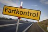
France looks "incroyable". Really great job. I explored the map a bit yesterday (this is from a ProMods newbe) and it was just "wow!" after every second turn. Small villages, beautiful scenery, many little details. But I have a question: I found several sections with roadworks (both on motorways and on country roads) where there were no specific speed limits. Don't they do such thing anymore in France? Or are these roadworks sections still under construction (pun intended) and the signs will be added later?
Schöne Grüße
Chris
Schöne Grüße
Chris
-
freddele68
- Posts: 7
- Joined: 10 Aug 2014 11:25
Bonjour
Felicitation pour cette avancé sur le centre de la France, et continuer ainsi.
J'espere que vous representerez bien Clermont pour un auvergnat comme moi avec les autoroutes A71 vers paris, A89 vers Bordeaux et Lyon, l'A75 vers le Sud, la N1089 de Bordeaux à Clermont Ferrand, le tout vue par la chaine des Puy et le Puy de Dôme
Petit question à part, y'aura t'il inclu la ville de Auxerre etant proche de l'A6??
Freddy
Bonne journée
Edit - Google Translation (since this forum is in English):
hello
Congratulations for this advanced on the center of France, and keep going.
I hope you will represent well Clermont Auvergne as for me with the A71 to Paris, Bordeaux and Lyon to A89, A75 to the South, the N1089 from Bordeaux to Clermont Ferrand, all seen through the chain of Puy Puy de Dome;)
Small issue aside, y 'will you it included the city of Auxerre being close to the A6 ??
Freddy
have a nice day
Last edited by stummer on 08 Oct 2014 09:12, edited 1 time in total.
Reason: Please post in English here - we have a French speaking forum: http://www.promods.net/viewforum.php?f=19
Reason: Please post in English here - we have a French speaking forum: http://www.promods.net/viewforum.php?f=19
Hey French Guys, you must respect rules of forum and write your post in english please
 I will correct this ASAP
Problem will be same with Clermont and Puy-de-dome Mountain. I will do the better I can do... but I can have big surprise
Return on N145, Gueret - Montluçon Axis, with pictures of Creuse River and Montluçon
I hope build map with Corsica Island after I covered all french territoryVladzz-G wrote:OK.
I know, that you also at start not planned to build Corsica island, with cities, like Ajaccio, but Corsica island also is in "Full French territory covering" plan, or you will build France without Corsica?
There are too much things to do...BarbeQ wrote: Don't they do such thing anymore in France? Or are these roadworks sections still under construction (pun intended) and the signs will be added later?
We are working at 1/10 with mapping. But it's not simple because road, models and all object have real size. Example with Mont Saint Michel. This mountain is far from road in real but with mapping there is closed from road. This is mapping effect.freddele68 wrote: I hope you will represent well Clermont Auvergne as for me with the A71 to Paris, Bordeaux and Lyon to A89, A75 to the South, the N1089 from Bordeaux to Clermont Ferrand, all seen through the chain of Puy Puy de Dome;)
Small issue aside, y 'will you it included the city of Auxerre being close to the A6 ??
Problem will be same with Clermont and Puy-de-dome Mountain. I will do the better I can do... but I can have big surprise
Return on N145, Gueret - Montluçon Axis, with pictures of Creuse River and Montluçon
- Attachments
-
- 2014-10-08_00004.jpg (415.22 KiB) Viewed 2602 times
-
- 2014-10-08_00003.jpg (476.16 KiB) Viewed 2602 times