Page 89 of 95
Re: [TUTORIAL] A tutorial creating map (1.8.2)
Posted: 05 Nov 2016 22:19
by deco13
Hello, I've another problem.
I'm trying to make my custom map overlay for roads.
How I create the tobj and mat file? I create the folder structure and the dds texture and now?
I don't find any tutorial or guide about on there site and scs forum or google.

Re: [TUTORIAL] A tutorial creating map (1.8.2)
Posted: 05 Nov 2016 22:38
by Vøytek
You can copy already existing files and just change file name. Try it.
.mat files - open with Notepad or Notepad++
.tobj files - open with ETS2Studio. This program has built-in TOBJ editor.
Re: [TUTORIAL] A tutorial creating map (1.8.2)
Posted: 05 Nov 2016 23:59
by deco13
Thanks, it works!
Re: [TUTORIAL] A tutorial creating map (1.8.2)
Posted: 13 Nov 2016 19:01
by EG0611
Who can explain the logic behind cutplanes? Because it cannot be only drawing lanes and hoping it will work, there has to be a logic behind it.
I watched Mandelsoft's video (
https://www.youtube.com/watch?v=7IFJttG9TRc ) but it is like teaching us 2 + 2 = 4 and then showing us what is d(x^2 + ln x + e^x * 3(e^x+ln x))dx .
Re: [TUTORIAL] A tutorial creating map (1.8.2)
Posted: 13 Nov 2016 19:24
by Vøytek
I never used it but I think it works like that (it's very simple example):

If you're a Player, driving that road at the top of my drawing, you can't see city because of trees + hill. So you place a cutplane behind the hill, to hide city. Only some high buildings will be visible if you set "ignore cutplane" (I think there's such possibility). It's used to optimize. Why should game engine load whole city, if player can't see it anyway? You put a cutplane and that's all - city isn't visible. If you cross the red line (cutplane), then road + trees + hill will disappear, but city will appear to player. Now he's in city, so city needs to be visible but forest is not needed. Hill can be set to ignore cutplanes, so it'll be a natural barrier. You'll see it from the road and from the city.
Re: [TUTORIAL] A tutorial creating map (1.8.2)
Posted: 13 Nov 2016 20:36
by EG0611
Thank you Zniwek but what you explained is what I meant as "2 + 2 = 4"
What I was asking was this;
There has to be a logic in order to make people don't see the other sides of RED lines from any angle including highway <> city connection road. On the other hand when I go and take examples from Promods city, they confuse me more. White red and yellow cut plane lines from everywhere to everywhere.
Re: [TUTORIAL] A tutorial creating map (1.8.2)
Posted: 13 Nov 2016 22:11
by ETS2-User
Have you tried to append nodes to a cutplane?
Re: [TUTORIAL] A tutorial creating map (1.8.2)
Posted: 14 Nov 2016 06:48
by EG0611
ETS2-User wrote:Have you tried to append nodes to a cutplane?
My problem is beyond appending, removing nodes or making it one side. My problem is understanding the logic. Here let me show you:
Actually I solved it by "ignore cut plane" option of these roads, prefabs and terrain so this is solved.

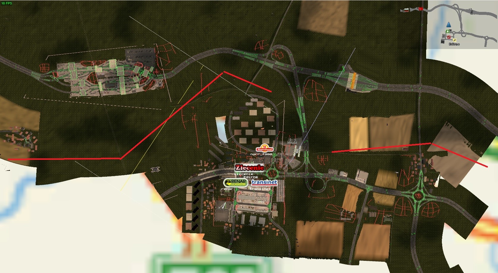
The problem is this:

No matter what I do in this particular point everything is seen and game performance drops. And because I don't understand the logic, I cannot fix it. Maybe if I can rotate node I can solve it but it doesn't allow me.
Re: [TUTORIAL] A tutorial creating map (1.8.2)
Posted: 17 Nov 2016 07:56
by EG0611
I feel like I am asking secret formula of Krusty Krabs. Seriously no one in here or SCS forum knows the logic behind cut planes? There has to be otherwise how it has been done until now? Don't tell me try and error method.
Re: [TUTORIAL] A tutorial creating map (1.8.2)
Posted: 17 Nov 2016 20:12
by HixoPL
You can't rotate cut planes. When you place cut plane, it's for one direction only, even with appending nodes you can't "rotate" that direction. Fix for it is just placing second cut plane
