Page 1 of 7
The Scandinavian map plan
Posted: 01 Aug 2013 12:12
by ScuL
This is our initial working plan;
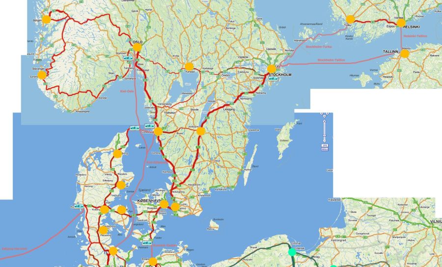
- 738322_371137829649275_2108659339_o.jpg (99.32 KiB) Viewed 29229 times
The red routes are roads we built and the orange dots cities we built.
When this was created it didn't include all routes later added such as E39 Kristiansand and some Swedish roads.
direct link:
https://fbcdn-sphotos-d-a.akamaihd.net/ ... 9339_o.jpg
Re: The Scandinavian map plan
Posted: 01 Aug 2013 19:14
by roxtmb
I can't wait to drive through narrow Scandinavian forests!
Re: The Scandinavian map plan
Posted: 01 Aug 2013 19:33
by Arcticwolf
roxtmb wrote:I can't wait to drive through narrow Scandinavian forests!
thats a MUST admins forest runs!.
Re: The Scandinavian map plan
Posted: 01 Aug 2013 20:34
by Gazer75
Suggest adding Rv. 9 Haukeli-Kristiansand when E134 is added

Also Fv. 7 along Hardanger fjord would be pointless imo. Its never used for long haul trucks unless E16 is closed.
Had this happen earlier this year. Complete chaos when trucks met on a road averaging 4-5m wide
Re: The Scandinavian map plan
Posted: 01 Aug 2013 20:38
by bjojen
Gazer75 wrote:Suggest adding Rv. 9 Haukeli-Kristiansand when E134 is added
If there is room, the scale of the game is far away compared to reality.
Re: The Scandinavian map plan
Posted: 01 Aug 2013 20:48
by Nico
No there wouldn't be any room for that.
Most countries only have the bigger E roads ( 2-3 lanes). Norway is mostly single lane roads. We also added the rv13 and the rv7 with some smaller challenging parts.
Re: The Scandinavian map plan
Posted: 01 Aug 2013 23:14
by roxtmb
Hmm what about Bronholm? Small island on Baltic sea.
Re: The Scandinavian map plan
Posted: 01 Aug 2013 23:16
by ScuL
roxtmb wrote:Hmm what about Bronholm? Small island on Baltic sea.
Yea the scale of ETS2 doesn't really allow that to be there.. you could probably see it from the Polish coast

Re: The Scandinavian map plan
Posted: 02 Aug 2013 03:07
by Gazer75
Nico wrote:No there wouldn't be any room for that.
Most countries only have the bigger E roads ( 2-3 lanes). Norway is mostly single lane roads. We also added the rv13 and the rv7 with some smaller challenging parts.
If you manage to fit hwy 11Denmark/B5 Germany, then I see no reason the Rv. 9 wouldn't fit.
The distance between the 11 and E45 in Denmark is pretty close.
Re: The Scandinavian map plan
Posted: 02 Aug 2013 19:10
by roxtmb
ScuL wrote:roxtmb wrote:Hmm what about Bronholm? Small island on Baltic sea.
Yea the scale of ETS2 doesn't really allow that to be there.. you could probably see it from the Polish coast
I can, but there must be great weather!